

 905-477-3600

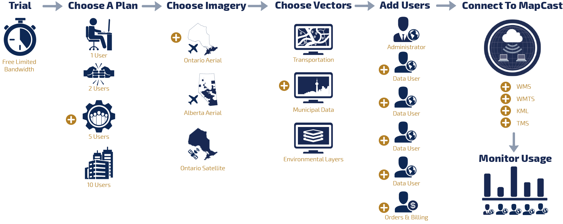
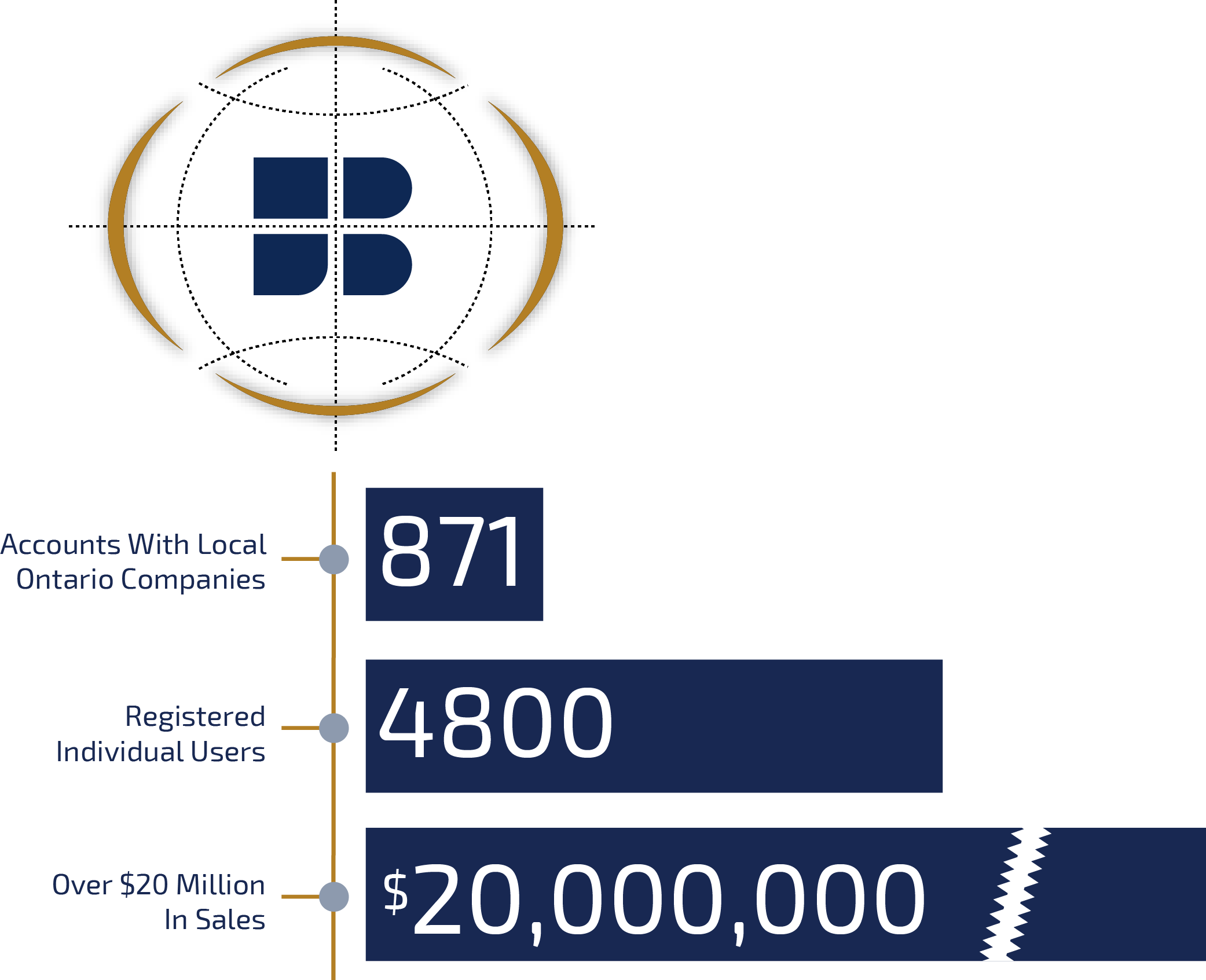
Increase Your Geospatial Intelligence
Imagery on demand

Stream high resolution imagery for Ontario and Alberta to your desktop mapping software using the WMS, WMTS, KML, or TMS protocol.
Shared subscription plans scale to the size of your team, or let us design a custom solution for your enterprise or web portal.
 Blog: MapCast Troubleshooting Checklist
Have you tried turning it off and turning it back on again? The top roadblocks to success with your MapCast subscription and how to address them…
Have you tried turning it off and turning it back on again? The top roadblocks to success with your MapCast subscription and how to address them…

CONNECT
Connect to FBS‘s aerial imagery and data collection through your desktop CAD or GIS software.
![]()

DISPLAY
Load a map-scaled photo mosaic base layer covering Southern Ontario or Alberta.
![]()

ANALYZE
Gain new insights by viewing your data in context with the surrounding area over a highly detailed image.
![]()

EXPLORE
Go back in time to review year over year land use changes at your area of interest with vintage imagery.
![]()


MapCast Connects With Software You Already Use


Blog: How To Use A Tile Map Service
If you can use Google Maps, then you’re already an expert. It’s much easier than you think…
If you can use Google Maps, then you’re already an expert. It’s much easier than you think…
Data Catalogue
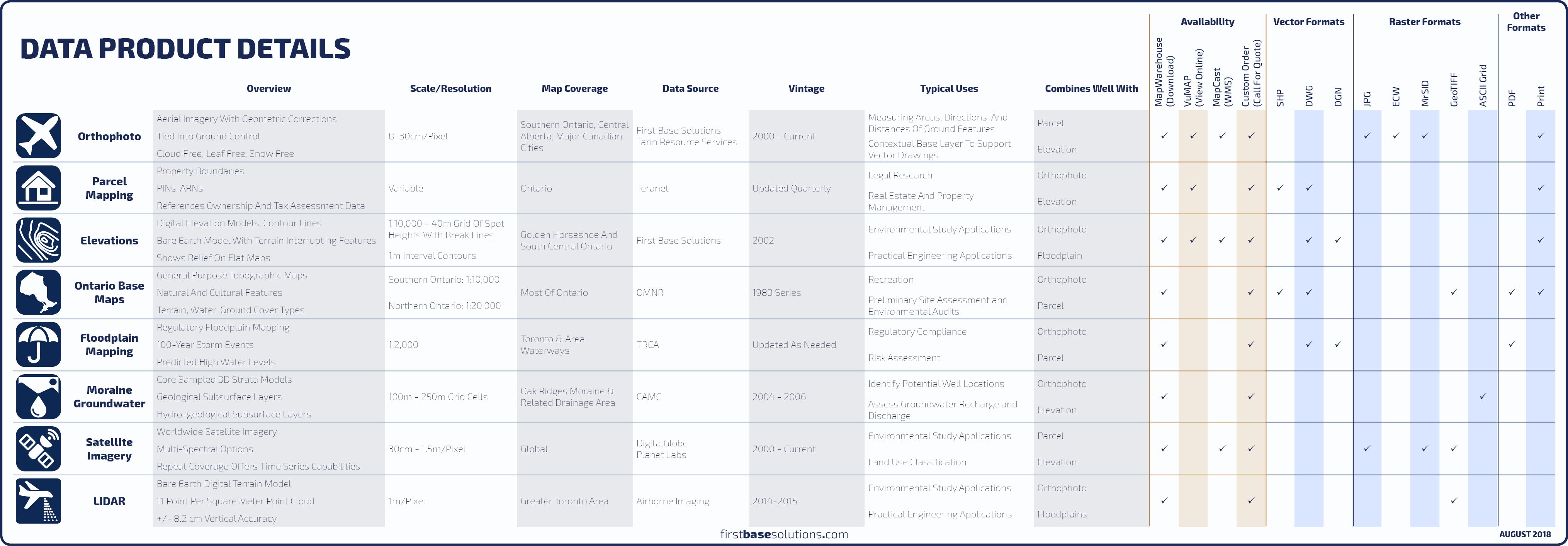 Compare All Data Products
 Orthophoto
An orthophoto is an aerial photograph geometrically corrected such that the scale and overhead perspective is uniform, enabling users to measure true direction and distance. ![]() Compare With Satellite
|
Compare With Satellite
|
![]() FAQs
FAQs

 Elevations
Elevation contours in 1m intervals across the Golden Horseshoe produced by First Base Solutions, and coverage of all Ontario in 5m and 10m intervals. ![]() Compare Elevation Mapping
|
Compare Elevation Mapping
|
![]() FAQs
FAQs
Download Free Samples 
Features
- Current and historical imagery covering Ontario and Alberta
- Select from aerial and satellite imagery packages plus localized vector overlays
- Shared subscription plans scale to the size of your team
- Imagery projects on the fly to many datum and coordinate systems
- Coordinate with remote co-workers to access and view the same data at the same time
- Connect to all First Base Solutions Services with the same username and password
Benefits
- Connect to desktop mapping software using the WMS, TMS, WMTS, or KML protocol
- Add data to your project and connect to MapCast instead of a file stored locally
- No need to store, manage or process vast data sets
- Assign operator and account admin roles, create custom reports, and manage your subscription online
- Monitor each team member’s usage in real time
- Automated email alerts and notifications regarding your account
Blog: WMS? TMS? WMTS? MapCast Subscribers Take Your Pick
An explanation in plain English without the WTF. Here I’ll recommend which connection type to use and when…
An explanation in plain English without the WTF. Here I’ll recommend which connection type to use and when…
Pricing?
Select an annual plan based on the number of users, then select from aerial and satellite imagery products that match your area of interest. You can also select from free and premium vector overlays to add to your subscription.
Data prices scale with the size of your team, which can be upgraded at any time. Bandwidth overages are billed monthly. Build your subscription now for a personalized quote.
Blog: Tips To Sell Your Boss On MapCast
Leverage the rapport you have with your manager combined with the tips below to get your company on MapCast. Here’s how to talk to your boss like a boss…
Leverage the rapport you have with your manager combined with the tips below to get your company on MapCast. Here’s how to talk to your boss like a boss…
Who’s It For?


Blog: Easy To Use, Easy To Maintain, Works With Software You Already Use
Access all of First Base Solutions’ aerial imagery and elevation contours served directly into your desktop CAD or GIS software with MapCast…
Access all of First Base Solutions’ aerial imagery and elevation contours served directly into your desktop CAD or GIS software with MapCast…
Sell Your Data
FBS offers great partnership programs that make selling your geographic data easy and cost free.
We’ll sell your data on all our platforms to maximize your data’s distribution, allowing you to focus on what you do best: Creating More Data.
 Learn More
Blog: Ontario Orthophoto Mosaics Coverage Atlas
Download FBS‘s year by year ortho coverage PDF or bookmark this blog for updates…
Download FBS‘s year by year ortho coverage PDF or bookmark this blog for updates…
Discover More
-

-
Data Catalogue
-
-
Moraine Groundwater
-

-
Floodplain
-

-
Orthophoto
-

-
Satellite
-

-
Elevation
-

-
Frequently Asked Questions
-

-
FBS University