Tag Archives: law

  • 0

Ready, Set, Research! [Video]

Tags : 

Ready, Set, Research! [Video]RAQ: Creating a spreadsheet of legal descriptions of Teranet's parcel mapping using VuMAP

For a lightweight application, VuMAP sure does some heavy lifting when it comes to day to day productivity in your real estate or law practice. Today's rarely asked question highlights a simple but powerful built-in tool that will help speed up your research; the query tool.

  • Find the location on a map
  • Review the legal descriptions of parcels in the area
  • Bookmark the chosen properties
  • Download all the saved information to a spreadsheet

Ready, Set, Research! [Video] 

The video below will show you how to use some of the features you won't see with a free trial subscription.

Keep Reading »


  • 0

$100 Not Going As Far As It Used To?

Tags : 

$100 Not Going As Far As It Used To?Best $100 per month investment for your business

For a lot of us, $100 is a tank of gas. If you use that $100 tank of gas to drive your crew and equipment out to investigate various work sites, add your labour costs, plus any lost opportunity costs while your assets and gear are tied up on the road. That $100 tank of gas actually costs your business far more than face value.

If you’re reading his article, it means you’re interested in ways to streamline your operations so that $100 goes a little further. Here’s one simple way to do just that, and it’s completely free to try:  

$100 Not Going As Far As It Used To?

It will still cost you $100 every month, but, you can reduce the number of trips out of the office, effectively saving you that very expensive tank of gas and freeing up your employees and equipment to work on something more productive than sitting in traffic. If you save a tank of gas per month, it’s more than paid for itself!

What Can I Get Out Of VuMAP?

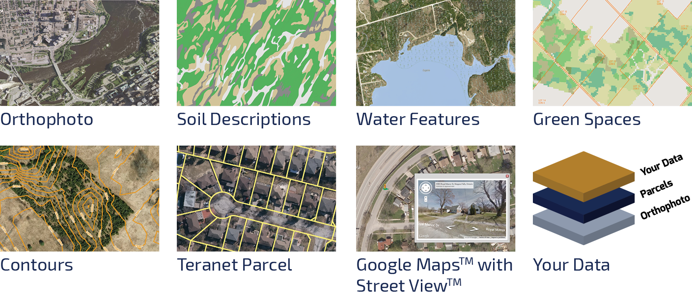
VuMAP gives you the freedom to jump online from anywhere you are, and compile a custom map view of your area of interest in seconds. Click to turn layers of aerial imagery and mapping information off or on, measure, draw, and add annotations to your map, or query features to learn more about them quickly.

$100 per month gives you unlimited access to research up to date mapping information including:

$100 Not Going As Far As It Used To?

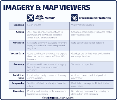
How Is VuMAP Different?

$100 Not Going As Far As It Used To?
Click to enlarge

    Show Me VuMAP in Action! 

    Watch the VuMAP tutorial:


    Who Is VuMAP For?

    Construction and Landscaping

    • Use VuMAP’s measurement tools to accurately find roof or pavement areas to estimate your material costs. 
    • Communicate your work plan with images identifying where bins and machinery can be located on site. 
    • Identify work site hazards and obstacles before the job begins.

    Land Development

    • Perform non-intrusive environmental assessments.
    •  Design to make the most of your site’s unique features.

    Renewable Energy 

    • Measure rooftop areas for solar panels and distances to grid tie ins.
    • See the context of the surrounding land use to identify the best potential locations.

    Natural Resources Management

    • Accurately measure acreage of woodlots to estimate harvest yields.
    • Monitor year by year changes to land use patterns. 
    • Research remote site conditions without the hassle of a ground survey.

    Legal

    • Research PINs for every property in Ontario along with boundary mapping to visually identify dominant and servient parcels.
    • Compare current and historical imagery to objectively show past conditions at a property.
    • Measure distances and sight lines to reconstruct accident scenes.

    Listen to VuMAP users like civil engineer Michelle Tremblay and hydrogeologist Steve Usher talk about how VuMAP helps them save money and work more efficiently.

    The Offer:

    What’s the best way to invest $100 a month in your business? Invest in a VuMAP subscription.  Here’s how:

    1. Start with a free trial. Free means free. Really. You’ll get 1 week to try the application with unlimited access (certain third party data is not available during the trial).

    2. Contact customer service and we will set up a promotional pricing subscription for you. New subscriptions starting between October 1st, 2016 and January 31, 2017 will receive the promotional price of $1200 + tax for a single user license.* That’s only $100 per month!

    (If you’ve got a whole team that needs VuMAP, call us.)


    *Offer is for new subscribers and does not apply when renewing an existing active subscription. May not be combined with other offers. After 1 year, regular price of $1500 + tax will apply upon renewal.  Other conditions may apply. 

    $100 Not Going As Far As It Used To?

     Questions? 


    $100 Not Going As Far As It Used To?

    Call (905)-477-3600 ext 280 or info@firstbasesolutions.com
    $100 Not Going As Far As It Used To?

    • 0

    Just For Law: Montreal

    Tags : 

    Just For Law: MontrealBonjour Law Clerks!

    Join First Base Solutions in Montreal, May 11-14 2016, for the 26th annual Institute of Law Clerks of Ontario Conference: Just For Law.

    First Base Solutions is proud to be a silver sponsor at this year’s event.  Visit our booth, stay and chat, watch a demonstration. Learn how to integrate our mapping technology into your legal work.

    Related: Law Of The Land – Use mapping and aerial imagery to enhance your legal research

    We’ll be demoing VuMAP, a feature-packed online mapping application that lets you measure, draw, compare imagery year over year and research land information from anywhere through a web browser.

    • Save time and money on site research
    • Evaluate locations without leaving the office
    • Make decisions based on facts not guesses
    • Communicate complex information visually
    • Did I mention there’s a free trial?

    Related: Adverse Possession – Law of the Land: Goode v. Hudon, 2005

    Legal firms were some of the first companies to utilize geodata in their daily processes. By reducing up front cost and time, they are able to provide a better service while making higher margins.

    Check out the two articles below and see how FBS is helping legal firms reduce their costs:

    Related:  The Secret Weapon for Difficult Searches
    Related: Top Three Ways Location Intelligence Helps Lawyers

    See you in Montreal!


    • 0

    Liquor License Restrictions

    Tags : 

    Liquor License RestrictionsLaw of the Land: Safari Bar and Grill Inc., 2008

    No matter what kind of law you practice, brushing up on your geography skills can help you quickly get to the root of land based legal research. Read below to see how mapping and aerial imagery is being utilized in Canadian law:

    Related: Law Of The Land

    Application To Remove Liquor License Restrictions: Safari Bar and Grill Inc., 2008

    The liquor license application process involves hearing the feedback and objections of local residents who do not want the character of their neighbourhood to be degraded by an increase in alcohol visibility, noise, traffic and parking issues.


    Overview

    Safari Bar and Grill has operated without any liquor violations or complaints from local residents for many years. At the time they were first granted a liquor license, a bylaw prevented them from serving alcohol on their outdoor patio, as the neighbourhood was considered too residential at the time. The bylaw was changed, and newer businesses with patios were permitted to serve alcohol outdoors. Safari applied for removal of their liquor license restriction, citing a competitive disadvantage. Before the the application could be approved, local residents’ objections related to possible noise and public intoxication had to be considered first.

    Outcome

    The application was approved. Safari overcame the objections by demonstrating service on their patio was unlikely to degrade the character of the neighbourhood.

    How Were Maps And Aerial Imagery Used In This Case?

    The establish quantifiable facts of geography.

    Quantitative Analysis

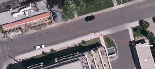
    The applicant was able to demonstrate by measuring distances over aerial imagery that the closest residential neighbour to his patio was more than twice the distance away compared to the distance between the nearest residential neighbour and the patio of a similar business a few blocks away.

    Municipal objections to serving liquor on the patio were no longer an issue. Safari overcame the objections of residents by demonstrating the hesitations about potential noise problems were based on perceptions, not reality.

    Related: Top Three Ways Location Intelligence Helps Lawyers


    • 0

    The Tort Of Nuisance

    Tags : 

    The Tort Of NuisanceLaw of the Land: Smed v. Priddis Greens Golf & Country Club, 2011

    No matter what kind of law you practice, brushing up on your geography skills can help you quickly get to the root of land based legal research. Read below to see how mapping and aerial imagery is being utilized in Canadian law:

    Related: Law Of The Land

    The Tort Of Nuisance: Smed v. Priddis Greens Golf & Country Club, 2011

    When one party’s activities become disruptive to another party, a claim can be made for damages related to the nuisance.

    Overview

    The defendant, a golf and country club, was licensed to store treated wastewater in ponds that formed water hazards as part of the course. They were permitted to use this water resource to irrigate the course in times of dry weather and to periodically discharge excess wastewater into a ditch where it drained through a culvert, across neighbouring land, and emptied into a creek in times of wet weather.

    The plaintiff, the neighbour on the receiving end of the discharge, claimed damages for erosion, soil contamination, and to pay for flood mitigation on 8-9 acres of rural land. She also claimed damages for trespass, nuisance, and negligence.

    Outcome

    The plaintiff was awarded $10,000 for loss of enjoyment of her land during the times of discharge. The balance of her claim for damage to her land caused by flooding was dismissed.

    How Were Maps And Aerial Imagery Used In This Case?

    As objective records of the past. 

    Establishing The Physical Features Of The Site

    Maps are the easiest way to communicate the physical arrangement of the properties and how they relate to one another. Especially important to this case in particular is the topography which decides the natural drainage features and determines how the water will move across the land.

    To Quantify Changes To The Condition Of The Property

    Both parties engaged the services of geotechnical experts to give their opinions on the condition of the land in question. Both sets of experts agreed the land was swampy and poorly drained based on inspecting the site at the time the claim was made. Although the claim for damage to the land was dismissed, aerial imagery serves an important role in measuring the acreage of land in question which is necessary to estimate its value.

    The experts for the defense also prepared a historical analysis based on a review of aerial imagery. They found by measuring the percent of canopy cover over a 40 year period at the affected site that no change in the cover had occurred, and that the area was part of a naturally occurring floodplain that existed before the golf course was established. They found the species of trees at the site were well suited to poorly drained soils and were tolerant to occasional flooding.


    Related: Top Three Ways Location Intelligence Helps Lawyers


    • 0

    Law Of The Land

    Tags : 

    Law Of The LandUse mapping and aerial imagery to enhance your legal research

    Maps are an essential tool to interpret other documents. Visual materials are naturally easy to present and explain to others. No matter what kind of law you practice, brushing up on your geography skills can help you quickly get to the root of land based legal research. Read below to see how mapping and aerial imagery is being utilized in Canadian law.

    Maps and aerial imagery can be used as independent, objective sources of information to support other facts. Interpretations and conclusions made based on geographic data can be refuted just like any other opinion. Understanding how to use maps effectively is essential to your practice since the creation and distribution of spatial data has become mainstream and highly accessible through online applications such as Google Maps and VuMAP.

    Virtually every industry has inserted modern mapping into some aspect of its standard operating procedures. Expect this trend to continue. Law being incredibly multifaceted, using maps and aerial imagery in legal practice can be grouped into three basic strategies:

    Time Series

    Aerial imagery is an object record of the past that can be used to answer questions about conditions that once existed at a location. Since aerial imagery is continuously updated, it’s an easy way to visualize changes as they occurred over time.

    Measuring

    Aerial imagery is usually geometrically corrected to compensate for the movement of the aircraft such that the viewer’s perspective is directly overhead at all points in the photo. Accurate measurements of distance, area, and sight lines can then be taken directly over photographic detail.

    Research and Pre-Search

    Maps can help fill in the gaps and provide an alternative credible source where other reference materials may be difficult to locate, interpret, or explain to others. Of course any land based activities that need to be researched can be expedited with maps.

    Related: What You See Is What You Get?